App for measuring acreage

mrlnfshr1

New Member
Its been awhile since I've been on here. Now that I have time again, I'm looking forward to getting back into foodplotting for deer after about 5 years off. The landowner of the farm I hunt wants to get an updated acreage estimate of the land that his farmer is tilling. Can anyone recommend an app for an Android phone that is easy to calculate this with. I seem to recall that there was at least one that was as simple as driving the field edges and saving waypoints at various spots like corners. Thanks
 
Google Maps
Right click and measure distance
Make a square
Take the total sq ft and divide by 43,560 to get acreage
 
Fields Area Map. I haven't used this app in a while, but it always worked well for me in the past. Just drive around the field and it calculates it.
 
Download the app "Google My Maps" and then you can use that to outline the field and when you close a line around an area it will automatically tell you the acreage. Although lines can be drawn in the field I usually just insert a point at all the various corners of the field, then open the same map on my PC (which is as simple as googling my maps and entering the same username) and draw my field lines from point to point. The main thing I like about "My Maps" is the ease of drawing on a large screen in my office, then going out in the field on my phone and drawing more on the same map, or vice-versa. We use this app to mark our property lines, fields, trails, stand locations, prevailing wind directions, acreages, and deer kills on different layers of the same map.
055981656f828378d7a2fef04ddd23c9.jpg
 
I like draft logic or use the ruler on google earth and times it for square footage
I compared draftlogic to surveyor numbers and it was very accurate. They have both distance and area maps.

Sent from my SM-N960U using Tapatalk
 
Thanks for the replies. Fields Area Measure looks like it may be what Im looking for. An actual on the ground app, not a PC based image. Trying to avoid ranging and calculating.
I'm familar with Google earth etc, but the problem is some of the fields are partially obscured by trees and you cant see the actual field edge. Just looked at Acme Planometer and it doesnt show property lines, let alone field edge.
 
Maybe it's inconsequential, but there are a lot of accuracy issues to consider. Each application and method of collecting a latitude and longitude suffers some amount of error. I don't know about Android phones. I guess they have a GPS chip in them? That's better than cell tower triangulation, but even GPS has issues. I know the newer iPhones have a better ship set than older ones. Any handheld app you use to calculate acreage can suffer from data loss. It's probably better now, but some apps didn't (don't) use all the points you collect to calculate whatever it is you're trying to figure. Again, all this might not be an issue for you, but it is something to keep in mind.
 
The apps probably aren't the most accurate but it sure is nice to size your plot while you are actually at the plot. I used the Fields Area Map the first time I was dividing a larger plot into 3 smaller plots. It also came in handy when doing a really wild shaped area with lots of curves for a switch grass bedding area. Sure was nice to make a lap of the area on the 4 wheeler and see that it's only 3/4 acre and you want a full acre for easy seeding rates. Definitely not accurate enough for real farming, but for a deer plot, it's fine. I couldn't see a difference when comparing to google earth later.
 
I was planning on using a couple different tools and compare. Google earth doesn't show an absolute straight down image of the farm. A couple field edges are not visible and therefore I am unable to get a remotely accurate measurement. Im waiting for the fields to dry enough to try a couple apps.
 
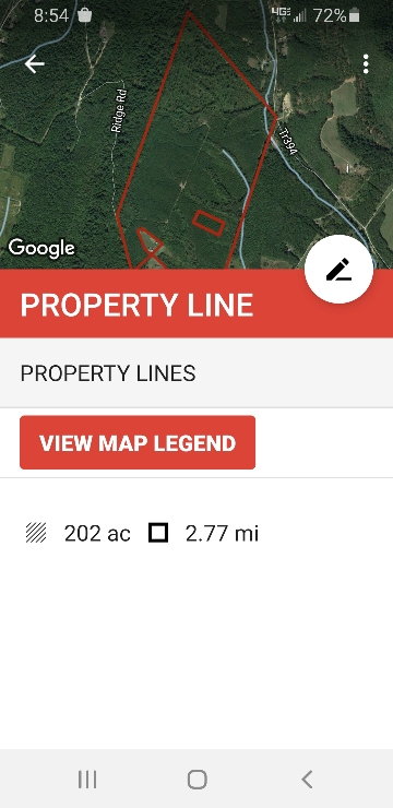
surprised no one said it yet.....OnX Hunt app.

I think I'm on my third year of using OnX.. I use the dang thing for everything.

Anyone ever find an issue with the measurements or lot lines? I find it really close to my surveyors measurements. Also, I do find it cumbersome to draw the measurements on my IPAD for calculations. Great for distance, but when I try to draw around a location for size its a real PIA. ..Maybe I need a pen or something to draw it out on the screen?
 
I was planning on using a couple different tools and compare. Google earth doesn't show an absolute straight down image of the farm. A couple field edges are not visible and therefore I am unable to get a remotely accurate measurement. Im waiting for the fields to dry enough to try a couple apps.
It doesn't matter if the Google earth satellite pictures aren't accurate exactly to the edge of the field because of picture and tree angles. I take my phone and physically drop a pin at the corner of my field on Google and that will give me a field measurement that's accurate to about 10'.
 
I think I'm on my third year of using OnX.. I use the dang thing for everything.

Anyone ever find an issue with the measurements or lot lines? I find it really close to my surveyors measurements. Also, I do find it cumbersome to draw the measurements on my IPAD for calculations. Great for distance, but when I try to draw around a location for size its a real PIA. ..Maybe I need a pen or something to draw it out on the screen?


I have found On-X and HuntStand to be off on their property lines, but because I wouldn’t depend on them for legal work it doesn’t make that much difference to me.
 
I have found On-X and HuntStand to be off on their property lines, but because I wouldn’t depend on them for legal work it doesn’t make that much difference to me.

They use GIS data, they’re lines will only be as accurate as your states/counties GIS mapping.


Sent from my iPhone using Tapatalk
 
Back
Top