You are using an out of date browser. It may not display this or other websites correctly.
You should upgrade or use an alternative browser.
You should upgrade or use an alternative browser.
Any free map making suggestions?
- Thread starter Flo1919
- Start date
Mennoniteman
Well-Known Member
The "Google-My Map" app/ program is exactly what you are looking for. This is a different program than Google maps, it is very simple, but very customizable. Satellite view, I have all our property lines on one layer, buck kills on another layer, doe kills on another layer, treestand on another layer etc. You can open on your smartphone or pc, but you can only change icons and line colors on pc. Download the app on smartphone and you can enter data offsite or enter pins on exact location if you have service.
Mennoniteman
Well-Known Member
Huntstand and several others do the same thing, just about the identical program. Huntstands disadvantages are more complicated and a lot of ads, their advantage is some adjacent property lines and owners names.
Cedar Ridge
Active Member
I want to be sure I’m looking at the right app. Is the Google app being suggested $2.99?
Jack Terpack
Well-Known Member
I have heard about this, but wonder if it is still supported. I can't find any that work for GEP.I would highly suggest Google Earth Pro. It’s free and has very high quality aerials with topo layer you can plug in for free.
Mennoniteman
Well-Known Member
Got it for free at "Google Play Store". Hey, I'm a mennonite, we can't turn down free. The biggest dilemma for a mennonite is free beer.I want to be sure I’m looking at the right app. Is the Google app being suggested $2.99?

Last edited:
HB_Hunter
Well-Known Member
I have heard about this, but wonder if it is still supported. I can't find any that work for GEP.
The topo layer?
Jack Terpack
Well-Known Member
Yes. I tried My Maps, but it won't install on a Mac and I do not have anything to do with Android.The topo layer?
Last edited:
pinetag
Well-Known Member
If you're talking PC's then you can just screen shot a topo (save it in paint) and insert the layer into GEP. You will likely have to shrink it to size and move it around but you can pretty much tell where things go using roads, rivers, fields, etc. to line it all up.Yes. I tried My Maps, but it won't install on a Mac and I do not have anything to do with Android.
Sent from my SM-G930V using Tapatalk
dogghr
Well-Known Member
I have this but where do you access the topo you speak of.? Looked last night and couldn't find that. Also very accurate on measuring food plots and such.I would highly suggest Google Earth Pro. It’s free and has very high quality aerials with topo layer you can plug in for free.
pinetag
Well-Known Member
Dogghr...see my comments above. The button is called "insert overlay" and looks like this...I have this but where do you access the topo you speak of.? Looked last night and couldn't find that. Also very accurate on measuring food plots and such.
Last edited:

suburbhunter
Active Member
Google Earth Pro is very good, that's what I use. I'll have to try the topo overlay.
suburbhunter
Active Member
Does it matter where you get the topo map from? Is any place better than the other for overlay purposes?
HB_Hunter
Well-Known Member
I use an active layer in Google Earth. You literally just check/uncheck it to turn the topo layer on/off. Please see attached for the .kmz file (in a zip file). Just download it to your computer/extract and open the kmz in in Google Earth then drag it to 'My Places'. Check it if you want to see topo lines, uncheck it if you don't. You can also play with the transparency of the layer if you want to see the aerial with it.
Attachments
") .
.HB_Hunter
Well-Known Member
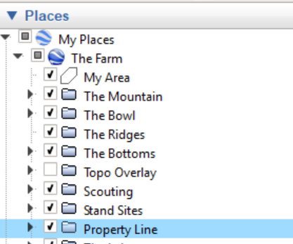
To the OP...I keep saying layers, which really isn't accurate. I have them organized in folders. This allows me to quickly hide things I'm not interested in seeing at the moment (past season scouting for example). I can simply uncheck the folder.
You mentioned the need to mark them up and I assume you are trying to get some ideas down. To do this, I create a folder and do all my markups in Google Earth. You can quickly copy/delete/move/save everything. You could also project it on a whiteboard (or some other surface you can write on) if you'd rather do that. Taking a screenshot and printing it is also an option.
You mentioned the need to mark them up and I assume you are trying to get some ideas down. To do this, I create a folder and do all my markups in Google Earth. You can quickly copy/delete/move/save everything. You could also project it on a whiteboard (or some other surface you can write on) if you'd rather do that. Taking a screenshot and printing it is also an option.